
Keyword Search
This Keyword Search button is the easiest way to find things.
TIPS:- Use quotation marks -- “626 W. Colorado”
- To narrow a search, use AND -- “Monrovia Days” AND “1986” to find only those.
- Try different spelling -- “626 W Colorado”, “626 West Colorado”
- Searches are not case sensitive (you can use MONROE, Monroe, or monroe).
- Keyword Search doesn’t look inside a document. You must open the document and hit the Control or Command key on your keyboard plus the ‘F’ key to open a window that lets you search within the document for a specific phrase.
Keyword Search Results
9 results found.
-
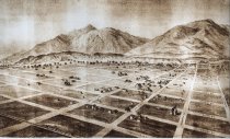
Bird's Eye View of Monrovia in 1886 - c. 1886
A map of Monrovia from Daffodil on the east to Mayflower on the West, Chestnut on the south to White Oak (Foothill) on the north. Shows orange groves north of Foothill, large homes at the base of the mountains, the Grand View Hotel, the Woman's Club, Granite bank and a scattering of buildings on Myrtle Avenue. Railroad track at south end. Before the 168 homes that had been built by the end of 1887.
Record Type: Photo
-
Map of Hosmer's Subdivision - 1887
Lots in 27-34 and Block M in Monroe's Addition to Monrovia Tract. Shows Mayflower Avenue, Jay Eye See Avenue [JIC, later Alta Vista -- named for J.I. Case's race horse], White Oak Avenue (Foothill), and Concord Avenue.
Record Type: Documents

-
Map of Tract No. 7000 in Monrovia - c. 1962
Assessor's map showing lots on Madison, Lincoln and 5th between Hillcrest and Foothill.
Record Type: Documents
-
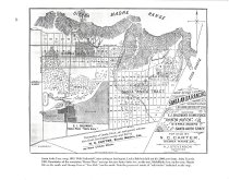
Monroe's Addition to the Monrovia Tract
Notes Lot #6 with Blocks 1-N at the time of the subdivision March 20, 1888. Most of the 275 acres of the Santa Anita Tract William N. Monroe purchased from Elias J. Baldwin. Mentions A.M. Spence and C.O. Monroe. Handwritten corrections believed made by Steve Baker.
Record Type: Documents
-
-
San Gabriel Valley Rapid Transit depot marked on map - 1892
Shows it on Chestnut Ave, just west of Myrtle.
Record Type: Documents
-
Santa Anita Rancho Map & First Purchasers - 1883
Map of the Santa Anita Rancho by H.J. Stevenson and notes on First Purchasers handwritten by Steve Baker including Keefer, E.J. Baldwin ("EJB"), Falvey and Bowman.
Record Type: Photo
-
Southern Pacific Depot marked on map - 1897
Shows "RR depot SP Co." on Chestnut Ave, just east of Myrtle. Also showing is the L.W. Blinn Lumber Co's Lumber Yard.
Record Type: Documents
-
Value of Improved Properties in Monrovia in 1888 - 1888
Transcribed notes from the Tax Assessor's Ledger of the Lot #, Block # and Value of Improvements on properties in Monrovia in 1888 with a map showing the location of the town's lots.
Record Type: Documents