
Search Term Record
Metadata
Name |
Streets |
Related Records
-
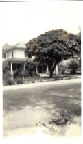
207 S Magnolia
Former home of Robert and Belle Long and their daughter Ella. On back, it says that it looks like it; there was a vacant lot at right.
Record Type: Photo
-
210 Freeway at night - c. 2000-2005
Looking wast on the 210 Freeway from the Howard Johnson Hotel on Huntington Drive.
Record Type: Photo

-
-
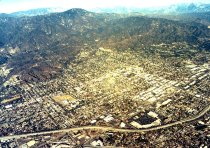
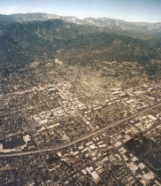
Aerail Photo of Monrovia - c. 1990-2000
Aerial photo of Monrovia looking northeast.
Record Type: Photo
-
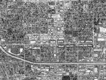
Aerail Photo of Monrovia - c. 1990-2000
Aerial photo of southern Monrovia looking east.
Record Type: Photo
-
Aerial photo of Monrovia - c. 1990-2000
Aerial photo of Monrovia looking northeast.
Record Type: Photo
-
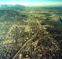
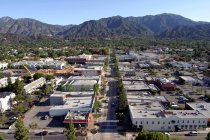
Aerial photo of Monrovia - c. 1990-2000
Aerial photo looking down on Old Town and 210 Freeway.
Record Type: Photo
-
-
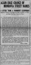
Again Urge Change of Monrovia Street Names - 1911
A prominent Woman's Club member suggest changes to street names. Article from January 31, 1911 mentions Alta Vista, Huntington, and Canyon.
Record Type: Photo
-
A Street with No Name - 2019
The History of Alta Vista Avenue and J.I.C. Street and J.I. Case.
Record Type: Documents

-
Aunt Betty's New Grievance - 1911
Article dated June 30, 1911 from "Aunt Betty" complaining about the naming of J.I.C. street. She suggests that Banana could have been "Potato Avenue", or "Sweet Potato Avenue". Seems a tongue-in-cheek diatribe, (written by whom?) to which W.N. Monroe reponded in his article on July 1, 1911. See OBJ ID: 111.
Record Type: Photo
-
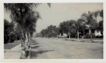
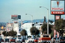
Auto Dealers Along Huntington Dr. - 1980
Auto dealerships lined Huntington Dr. in Monrovia through the 1980s, the last one leaving for a Monrovia Redevelopment Agency created, freeway-adjacent auto mall in 1991.
Record Type: Photo
-
B & G Subdivision - 1887
Lot D Block 2 and Lot C Block 2. Request of L.H Green.
Record Type: Documents
-
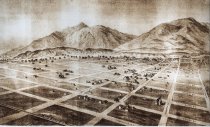
Bird's Eye View of Monrovia in 1886 - c. 1886
A map of Monrovia from Daffodil on the east to Mayflower on the West, Chestnut on the south to White Oak (Foothill) on the north. Shows orange groves north of Foothill, large homes at the base of the mountains, the Grand View Hotel, the Woman's Club, Granite bank and a scattering of buildings on Myrtle Avenue. Railroad track at south end. Before the 168 homes that had been built by the end of 1887.
Record Type: Photo
-
Blair's Subdivision - 1887
Lots 25-27 of the Stewart Subdivision of Lots 22-24 Block K of the Original Town of Monrovia. Request of R.A. Blair.
Record Type: Documents
-
Brook Edmonston's Subdivision of Lot C - 1887
Part of Lot 446 Santa Anita Tract. Shows Palm between Pansy (now Alta Vista) and Mayflower. Request of B. Edmonston.
Record Type: Documents
-
Businesses in Monrovia c. 1953 - c. 1953
Auto, Bakers, Barber Shops, Beauty Shops, Bowling Alleys, Cameras, Clothing, Department Stores, Drive In Restaurants, Druggists, Grocery Stores, Hardware Stores, Ice Cream, Music, Phonographs & Records, Shoe Dealers, Sporting Goods, Theatres. Primarily on Myrtle, Huntington, Foothill, Lemon, Lime, Shamrock, Colorado, Peck and Baldwin.
Record Type: Documents
-
-
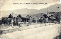
Charlotte Avenue, Mt. Wilson in the Distance
Charlotte Avenue was later named Canyon. Home at left is 435 N Canyon built in 1908. At right is 445 N Canyon built 1909. Taken from the northwest corner of present-day 430 N. Canyon, looking northwest. 435 N. Canyon is in the foreground and 445 N. Canyon is to the right. 445 N. Canyon still has one of those stones with a hitching ring at the curb, like the ones featured at many historic Monrovia homes.
Record Type: Photo
-
Chicago Park - South Monrovia - 1929
A layout of a section of "South Monrovia" that references the Rancho San Francisquito and shows street names of Michigan, State, Dearborn, Clark, La Salle and Randolph (all street names from Chicago). The original subdivision was recorded on March 12, 1888, during the land boom of the mid-1880s. Today it apparently is a subdivision in Arcadia. Most of the lots to the west of Myrtle are now part of the lake and the lots north of Clark are part of ...
Record Type: Documents